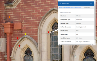
The way we record data during asset inspections is changing rapidly as new technology is developed. What was once a labour-intensive process is becoming increasing automated.
We asked Chris Stan-Bishop, the manager of our new Spatial Integration Division, to tell us about what is available in the realm of data capture technology today and what we can expect going forward.
Where are we now?
A variety of spatial data capture technologies and methodologies are available today and they can be broken down into three main categories:
Conventional Survey Measurement
This includes traditional manual methods.
Photogrammetry
Aerial camera (helicopter, aeroplane or unmanned vehicle) and ground-level capture.
Laser Scanning
Terrestrial, mobile (vehicle mounted) and aerial.
Duratec is focussed on highly accurate and very high detailed capture to allow for the best rendition of 3D environments and remote visual inspection and measurement. To make this possible, we combine both photogrammetry and terrestrial laser scanning to capture data with multiple commercial high definition ‘full format’ cameras, including professional prime camera lenses with minimal distortion.
By utilising high specification cameras mounted to unmanned vehicles, we are able to remotely capture and inspect hard to reach places as safely as possible and then build highly detailed and spatially accurate 3D models. This had not been previously possible using only terrestrial laser scanning or conventional survey techniques.
What will we be doing in the future?
Going forward, we will be seeking to enhance the speed and capability of our reality capture technologies to include SLAM based mobile laser scanning techniques/technology combined with high definition cameras.
SLAM (Simultaneous Location and Mapping) was originally developed for robot navigation and is the process of creating a map using a robot or unmanned vehicle that navigates that environment while using the map it generates.
This will enable the rapid capture of 3D data for large plants to an ‘acceptable’ accuracy (+/- 8mm) in situations where clients are more interested in having comprehensive 3D data with high definition imagery to remotely/virtually visit and inspect their assets. This will significantly reduce the time spent by staff and contractors entering the operational spaces of the facility.
What are the top new trends in this space?
Increased uptake in reality modelling across a variety of industries.
A shift to digital twins for optioneering and shutdown planning.
Linking 3D and digital twin models to the asset register, maintenance databases, CAD drawing warehouse and accounting.
What will the future look like?
Engineers and Project Managers will infrequently attend site and Estimators will not be required to attend site to provide quotations on works.
Detection and classification may be left up to the computer and the decision making process regarding repair is where staff will spend most of their time.


